 Sometimes, It's Great To Get Lost. By Kevin Franklin FINDING A LANDSCAPE unexplored by modern man has become nearly impossible. Hardly a square foot exists on this planet that hasn't been mapped or surveyed. With a moderate amount of research, one can acquire a fairly accurate picture of anywhere on the globe. Even places unseen by human eyes, like much of the ocean floor, are mapped and cataloged.
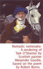
Exploration just isn't the same. That is, if you examine the entire body of human knowledge. On the other hand, if you're poorly organized and fail to make use of the information available, there's a whole world out there yet to be discovered. Standing in the midst of the Dripping Spring Mountains, I find myself experiencing this very brand of not-so-nouveau exploration. Some might even say I was lost. I like to think of it as "losing contact with my map." I know where I came from and how to get back there, but I'm not exactly sure where I am. My plan was to climb Tam O'Shanter Peak, in celebration of Robert Burns Day. Of course, I never quite got around to buying the appropriate topographical maps. I figured I'd use my Arizona Atlas & Gazetteer, an extremely handy collection of large-scale topo maps. The Gazetteer generally serves me well and has brought me to my current position without incident. However, standing in the midst of a large basin surrounded by a number of peaks, determining which is Tam O'Shanter Peak is a bit of a challenge. You see, there's no pinpoint on the map indicating exactly where the peak is. I have the name on the map and the general position, but Tam O'Shanter Peak is a long name. In fact, on the scale of my map, it's three miles long. Is the peak at the beginning, middle or end of the name? Peaks in other mountain ranges have pinpoints, but there's no consistent placement of the name in relation to the pinpoint. Deciding cartography can only carry me so far in circumstances like this, I fall back on English and maybe a bit of geography. After all, I know what a tam-o'-shanter is supposed to look like--one of these peaks must bear a resemblance.
I tighten my boot laces and set out. While very steep, the climb is straightforward. I reach the top and enjoy the view. Below lies the dormant mining town of Christmas. Off to the northeast runs the Gila River, with its thick stands of sycamore. From this vantage point I can see that the Gila River cuts a fantastic canyon through the Mescal Mountains. The area is full of towering crags and sheer cliffs. I decide then and there to explore that area in the near future. I descend the mountain and head to back to civilization. It's not until I get back to Tucson and examine some topo maps that I realize I climbed the wrong peak. I was a good three miles to the southeast, climbing an unnamed peak. Some might consider that a setback. Maybe even an egregious mistake. I say hogwash. Any fool can get to a specific geographic location given enough maps and global positioning units. Heck, the challenge today is to end up someplace other than you intended. It's the art of indeterminate wandering. It's the serendipity of the unknown trail. If you always end up where you plan to, you'll never discover the places you missed. Sometimes what you weren't looking for turns out to be even better. Columbus set out to find a western passage to India and ended up stumbling into a whole new hemisphere. So the next time someone says you're lost, just give them a wink explain that you're doing unscheduled reconnaissance. Next week follow Out There Guy to the ghost town of Mohawk. We're pretty sure he actually made it there.
Getting ThereThe Dripping Spring Mountains are 65 miles north of Tucson, just past Winkleman on Highway 77.
Mapage
The Hayden and Christmas 7 1/2 minute topographical maps
are trustworthy guides through these mountains.
|
 |


Home | Currents | City Week | Music | Review | Books | Cinema | Back Page | Archives
| © 1995-97 Tucson Weekly . Info Booth |
||
 The time has passed when a human could walk over a ridge, gaze
into a valley and know that nobody else had seen it before. Even
if humans reach Mars to plant the first footprints there, they
will not be sailing into the unknown like Lief Erickson or Columbus
did. They'll have maps, climate information and all kinds of useful
data about the place they're going.
The time has passed when a human could walk over a ridge, gaze
into a valley and know that nobody else had seen it before. Even
if humans reach Mars to plant the first footprints there, they
will not be sailing into the unknown like Lief Erickson or Columbus
did. They'll have maps, climate information and all kinds of useful
data about the place they're going.
 After some scouting I find what must surely be the peak. It's
vaguely beret-shaped and it has a knob on it that could pass for
a pompon after a few drams of whiskey.
After some scouting I find what must surely be the peak. It's
vaguely beret-shaped and it has a knob on it that could pass for
a pompon after a few drams of whiskey.