|
The Dragoon Mountains Have Been The Backdrop For Western History In Three Acts. By Kevin Franklin THE DRAGOON MOUNTAINS are neither particularly massive nor tall. They rise a mere 3,000 feet over the surrounding countryside. But their size didn't abate the fear people in Tombstone and the surrounding Anglo outposts had for them. This was Apache country, and the Dragoons were their stronghold. Even the name "Dragoons" is something of an incantation against the threat, real and perceived, the mountains posed for Anglos: Byrd Granger writes in Arizona's Names that the 3rd U.S. Cavalry Dragoons, posted here in the late 1850s, used the name "Dragoons" because of the heavy carbines they used instead of the standard swords and revolvers employed by other regional cavalry.
When Cochise died two years later, his followers buried him somewhere in these rugged mountains and concealed the site. Whether the burial site remains intact is for the Apache to know and no one else to find out. Today, geologist Bob Moulton and I are driving along Middlemarch Road east of the Dragoons, near the old mining town of Pearce. Our plan is to follow the Middlemarch Road over the Dragoons towards Tombstone. Some say the Dragoons named the route through the pass "Middlemarch" because it marked the halfway point on the patrol between Sulphur Springs and Tombstone, though locals point out the road goes through the middle of the Dragoons. In any event, the road is easily passable by most cars. As Bob and I are driving along, I imagine what it would have been like to be a tired cavalryman riding along this route. I'd bet they kept watchful eyes on the rocks and trees, cognizant that a well-aimed bullet could end their careers at any moment. I wonder if they dreamed of going back to safe homesteads in Ohio and Pennsylvania, or if the Apache themselves dreamed of such a change of heart for their inhospitable visitors.
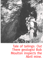
Long after the Apache were driven from the Dragoon Mountains, the area underwent a surge of mining. During the 1940s and '50s, the Abril mine, named after Tombstone brothers and mine owners Manuel and J.S. Abril, produced 30,000 tons of ore. Some of the higher-grade material assayed out at 49 percent zinc and four-and-a-half percent copper. By 1953 the mine was abandoned, except for a few small workings. Now it lies completely dormant. The tailings, headframe, hoist foundation and some other evidence remain. We meander through a towering grove of New Mexican locust plants along the old mine road. The shrub-like, 10-foot plants, with their fragrant purple flowers, contrast pleasantly with the moonscape of tailings piles. A squadron of bees swarm overhead, too busy to bother with us human intruders. The flowers have virtually covered one of the mine openings, and a cold breeze rushes out of the dark maw. According to Arizona Geological Survey documents, the mine workings extend for 3,000 feet through the flank of the mountain, and sprawl over five levels. It's like a natural air-conditioning system. Entering the mine is illegal, though, not to mention extremely dangerous. We leave the threatening-looking mine entrance, with its rotting timbers and warning sign complete with skull and cross bones, and head back up the road. The Apache, Dragoons and miners are gone from these mountains now, leaving the incredible vista across the San Pedro Valley to occasional explorers like us, and a few cattle.
For a pleasant loop drive, head east on I-10 past Benson to Dragoon
Road, at exit 316. Follow Dragoon Road east to Highway 191, and
follow that south until you reach Pearce. Take a right just before
the General Merchandise store on Cedar Street. Follow that west
until you see the sign for Middlemarch Road and FS 345. The turn-off
for FS 345A and Soren Pass is clearly marked. The Arizona Atlas
& Gazetteer is handy to have along for wayfinding.
|
 |


Home | Currents | City Week | Music | Review | Books | Cinema | Back Page | Archives
| © 1995-97 Tucson Weekly . Info Booth |
||
 In spite of the increased firepower, however, the Dragoon Mountains
belonged to the Apaches in every sense except for the lines drawn
on Anglo maps. The boulder chaos and the area's angular granite
peaks were ideally suited for the swift sniping tactics used by
the Apache. It literally would take an entire army to oust a few
well-placed and skilled men in these hills: Cochise and his band
of 200 never surrendered until the Chiricahua Reservation was
established in 1872.
In spite of the increased firepower, however, the Dragoon Mountains
belonged to the Apaches in every sense except for the lines drawn
on Anglo maps. The boulder chaos and the area's angular granite
peaks were ideally suited for the swift sniping tactics used by
the Apache. It literally would take an entire army to oust a few
well-placed and skilled men in these hills: Cochise and his band
of 200 never surrendered until the Chiricahua Reservation was
established in 1872.
 Near the top of the pass we come to the intersection of Forest
Service Road 345A with Middlemarch Road (a.k.a. FS 345). The secondary
road leads to Abril Mine, our destination for the day. This road
requires four-wheel drive or a determined driver in a rugged pickup.
If you're not up for abusing your vehicle, the 10-mile round trip
would make a good a day hike or mountain-bike ride.
Near the top of the pass we come to the intersection of Forest
Service Road 345A with Middlemarch Road (a.k.a. FS 345). The secondary
road leads to Abril Mine, our destination for the day. This road
requires four-wheel drive or a determined driver in a rugged pickup.
If you're not up for abusing your vehicle, the 10-mile round trip
would make a good a day hike or mountain-bike ride.