|
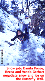
A Couple Of Pint-Sized Guides Cover New Ground In The Catalina Mountains. By Kevin Franklin "SNOW!" THEY SHOUT in unison and charge up the hill to revel in frosty pursuits.
"Let's go, girls," says ringleader Vanda Gerhart. "We're leaving now. There's more snow up ahead." Becca, Vanda's daughter, and friend Danita Ponce race back down the hill, onto the trail and off into the distance. I can see now that hiking with a pair of young girls requires the authority of a sled-dog driver and the negotiating savvy of Henry Kissinger. We're hiking down the Butterfly Trail in the Santa Catalinas. Eventually we plan to connect with Crystal Spring Trail, one of the lesser-used paths in the range, for about a five-mile hike. The aspens and sycamore trees in the Catalinas continue to hang onto their leaves, creating streaks of gold through the green pines. Small patches of snow glisten on the trail, and the weather is comfortable for hiking in shorts or light pants. But never underestimate the temperature change between the Tucson basin and the mountaintops. Always pack more than you need. If it's comfortable at the trailhead, you can leave the heavy stuff in the car; but keep in mind that as soon as the sun sets, temperatures will plummet to dangerous levels for the ill-prepared. At present, though, the temperature remains perfect for hurling snowballs at the old farts. Vanda and I find ourselves assailed by a squadron of compacted ice crystals. What this duo of pint-sized ice guns fail to realize is this particular Methuselah cut his teeth in the frozen wastes of Michigan, where the strong survive and the weak are encrusted in snowballs. A few well placed shots drive off our attackers. These snow pixies are easily frightened, but I suspect they'll soon be back and with greater ammunition. Fortunately, the rapidly descending altitude of Butterfly Trail is on our side, and soon the snow becomes little more than a distant memory. The girls, now tired from running around and chucking snowballs, start falling behind. The trail dives 800 feet in little over a mile. Naturally, the route takes a number of switchbacks. At the bottom of one of these switchbacks we call out to Pokey One and Pokey Two to get a move on. Planning may be an esoteric subject in the sixth grade, but geometry seems to come readily. The shortest distance between two points being a straight line, the girls take the direct path down a pine-needle covered slope. First attempt is sliding down the needles haystack style. This meeting with little success, tumbling is attempted. Finally, a flailing and sliding run emerges as the method of choice. We press on to the intersection with Crystal Spring Trail. About a half-mile onto this trail, the trees thin out and reveal stunning views of Mount Bigelow and the San Pedro Valley. The girls plop down on the trail and refuse to budge even after a snack.
"How much farther, and what's there?" asks Becca guardedly. "Crystal Spring... maybe we can go swimming," Vanda holds out as a temptation. "It's too cold." Temptation rejected. "It's a hot spring--you'll love it," I boldly lie with my best poker face. And away they go, charging down the trail, suddenly renewed. They tire again long before the spring and want to return, but not before I get to where I want to go. I think I'm getting the hang of this. On our way back up the mountain we run into a couple of huffing guys carrying a camera, no water and no pack late in the day. "Is there anything to see down there?" one puffs at me from the midst of a magnificent grove of Douglas fir and towering ponderosa pine. I doubt the possibility of a good snowball fight, a flailing rush at a slope of pine needles or the allure of a fictitious hot spring will meet his expectations. "I guess that depends on what you're looking for," I reply. Getting There
The Butterfly Trailhead begins a little more than two miles past the Palisade Ranger Station, off the Catalina Highway.
Mapage: The Santa Catalina Recreation Map serves well here.
|
 |


Home | Currents | City Week | Music | Review | Cinema | Back Page | Forums | Search
| © 1995-97 Tucson Weekly . Info Booth |
||
 "Uhh, girls. The trail is over here," I say to no one
in particular. The two 11-year-olds are already racing through
the pines.
"Uhh, girls. The trail is over here," I say to no one
in particular. The two 11-year-olds are already racing through
the pines.
 "Don't you want to finish the hike?" Vanda says.