

CONTROL ROAD DESCENDS from the north slopes of the Catalina Mountains into the range's northern foothills. Some say the epic journey is fraught with perils and tribulations. Others call it a joyride with nary a significant bump.
With these contrary reports in mind, the Out There reconnaissance team decides to investigate firsthand. Keeping the first law of four-wheel driving in mind (moving downhill is always easier than moving uphill) we decide to drive up the paved Catalina Highway and then down the Control Road.
This was not always an option. Completed in 1920, the Control Road was the first--and for 30 years the only--road into the Catalinas.
There were a number of reasons the north slope was chosen as the place for the first road up the mountain, Anne E. Harrison writes in her unpublished manuscript (kept on file by the U.S. Forest Service)The Santa Catalinas; A Description And History. The gentler grade of the north side and the fact that much of the work had already been done for a northerly approach--or would be paid for by mining interests in the area--were strong incentives.
 "...the Daily-Arizona Consolidated Copper Company offered
to build the section of the proposed road via the 3-C Ranch to
the Pima County Line if this route were accepted," Harrison
writes. "Pima County and the Forest Service would have to
build the last 10 miles from the county line to Soldier Camp.
However, two miles of this last 10-mile stretch had already been
rebuilt by the Stratton Copper Company."
"...the Daily-Arizona Consolidated Copper Company offered
to build the section of the proposed road via the 3-C Ranch to
the Pima County Line if this route were accepted," Harrison
writes. "Pima County and the Forest Service would have to
build the last 10 miles from the county line to Soldier Camp.
However, two miles of this last 10-mile stretch had already been
rebuilt by the Stratton Copper Company."
The clincher must have been when Pima County bureaucrats realized opening the Mount Lemmon resort area to residents of Pinal County would force the neighboring county government to help foot the bill, according to Harrison.
All roads lead to whomever pays for them.
When the road was completed in 1920, it proved quite an adventure for tourists of the day, with hairpin turns and erosion from summer storms. "Some of the early big touring cars had to run ahead and back," Glenton Sykes writes in an Arizona Historical Society ephemera file, "before they could make some of the curves...(and) during the summer storms, cars would get sideways across the road or hung in the deep drainage gutters against the inside bank."
Because the road was so narrow in some places, a control system was put into place to prevent vehicle stalemates. Starting at 8 a.m. with an uphill run, the last seven-mile stretch of road would become a one-way road for uphill traffic only. An hour and half later the direction would switch and it would be downhill traffic only, and so on throughout the day.
It was, in effect, Tucson's first suicide lane. If you didn't complete the seven-mile journey in time, you were supposed to pull over and wait for the right-of-way to reverse, or face a stiff fine ($50 in 1920)--or even a plunge off the mountain and a fiery death.
Some documents indicate as many as 100 cars would drive up to Summerhaven for parties on the weekends, so a control system certainly seemed to be in order. Driving down the road today, we encounter more than a half-dozen vehicles. Fortunately, the road is wider now, so we don't sweat the control system.
The road condition also has improved considerably. The combination of a better road and our sturdy four-wheel drive (going downhill) skews the adventure quotient of the journey considerably. I know an ancient Ford Granada that could make this trek without much difficulty, so if it's daring you seek, seek elsewhere.
On the other hand, the scenery and pleasantness of the trip are well worthwhile. And, although the road is hardly deserted, it's considerably more peaceful than the barbecue aqueduct known as the Catalina Highway.
While we are enjoying the view at one stop, a small herd of javelina scampers across the road near us. A lot of people mistakenly believe javelinas are "wild pigs." But Yar Petryszyn, University of Arizona ecology and evolutionary biology curator of mammals, says the javelina, or collared peccary, evolved from a family of critters unrelated to European pigs and boars.
They look superficially the same, Petryszyn says, because they fill a similar ecological niche. A snout capable of burrowing around for roots, tubers and grubs is one example of shared traits. But unlike the wild boar, javelinas are not aggressive, and, given the opportunity, will turn tail and run. Unfortunately for the hapless hiker, the javelina's poor vision may fail to reveal the most suitable direction in which to flee.
Petryszyn recalls a startled javelina that charged off and crashed into a barrel cactus, to the woe of plant and animal alike. When in the path of a frightened javelina, look out. If provoked and cornered, the generally peaceful animals have large and stout canine teeth (generally used to help crush roots and hard objects) which can cause tremendous damage.
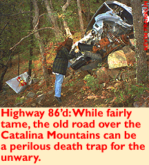
Generally speaking however, the biggest concern on the Control Road is the road itself. Farther down we see a truck that rolled off and down a rocky slope a few years back. But a steady hand and slow pace should guide you past any of these precipices without incident.
Before long we're off the steep section of the road and passing the Oracle Ridge Mine. Primarily a copper mine, this small operation was pushed into profitability by traces of gold and silver.
Past the mine, drivers are left with a choice. A turn to the right heads toward San Manuel, a turn to the left toward Oracle. A number of roads meander in the San Manuel direction and beckon to be explored someday. But today, it's growing dark and time to head back to Tucson.
GETTING THERE
Take the Catalina Highway up one-half mile past mile marker 24. Look for the turnoff to the right and the Control Road street sign. Follow the road straight past the Forest Service buildings and across a cattle guard into the wild blue yonder.Mapage: The Santa Catalina Recreation Map works well to guide your way. The new 1:100,000 scale Tucson topographical map is also available in a handy size for exploration.