|
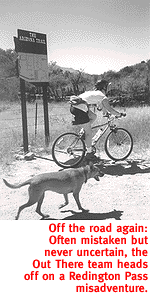
With The Hellish Summer Heat Abating, It's Time For Mountain-Biking Hell. By Kevin Franklin LET THE GAMES begin. Autumn has returned to Tucson, and with it another season of mountain-bike madness. Sure there are plenty out there who ride year-round, either by beating the sunrise to the trailhead or heading for the taller mountains.
To welcome the new season, the Out There navigational dart throw lands on Italian Trap trail in the Redington Pass area. Our adventure begins just past mile marker 12 on Redington Pass Road. About midway up a small hill a post indicates FS Road 37 and the way to Italian Trap. At this point we still believe the term "trap" refers to a natural rock configuration that captures rainfall and runoff--wiser are we now. The first two miles of FS 37 are a joy. The road winds its way down into a grassy valley and requires minimum skill. As things start to dry out in the post-monsoon season, the fall colors make a small showing here in the Sonoran Desert. The green leaves of the ocotillo are turning golden and dropping off. Ocotillos are drought deciduous, meaning they lose their leaves according to rainfall patterns rather than due to time and temperature, like maple trees. Like a conservative poker player folding his hand when the good cards stop showing, ocotillos drop their leaves at the first sign of drought. So while the changing colors whisking past on the trail have nothing to do with today being the first day of autumn, they do belie the notion that Arizona has no seasons. In what seems like mere moments we encounter the first major landmark on our route, the Arizona Trail. The trail descends from the top of Mica Mountain in the Rincons to this corral and then back up into the Catalinas. The corral has decent cold water for a head dunk, but I wouldn't drink it, unless you think the bacteria in your digestive system long for diversity. After the corral, the road takes a turn for the worse. Or I suppose you could say the wash the road descends into dramatically improves until it almost resembles a passage. Take your pick. I'm reasonably good at maneuvering through rocks. With a little headway, I've been known to plow through some deep, loose sand. I've even seen a successful river crossing or two in my mountain-biking career. But even on my best day there's not a chance in hell I could maneuver around thousands of rocks, through deep sand and cross large puddles and streamlets simultaneously. But for about a mile this is what the trail demands and, for us, where it earns its Italian Trap namesake.
If you're concerned with making good time, watch the topography on the map, keep good track of the distance traveled and take note of your compass heading. Any one of these would have directed us to the proper turn. Just keep in mind that if you always know exactly where you are, you'll never get lost. To me, that's half the fun of exploring. After crossing the wash, the route back to the trucks becomes pretty straightforward, though something of a hill-climbing slog fest. This road parallels the road we came in on by about a mile to the west. Eventually it comes out onto Redington Pass Road and leads back to the parking area. Next time we'll go counterclockwise, so that the smooth beginning of FS 37 and the downhill stretch of Redington Pass Road are on the tail end of the ride and the rock and more technical parts are at the start.
GETTING THERE
Take Tanque Verde Road east until it turns into Redington Pass
Road. Continue eight miles past where the paved road ends and
look for a clearing to park off to the right. The Rincon Mountain
Trail and Recreation Map is accurate, for the most part.
|
 |


Home | Currents | City Week | Music | Review | Cinema | Back Page | Forums | Search
| © 1995-97 Tucson Weekly . Info Booth |
||
 But if you're like our posse--unlikely to head out to the battlefield
before the crack of noon--rock hopping is best enjoyed during
the proper season. Around Tucson, that's just about the time water
coming out of the cold tap is slightly cooler than that of the
hot tap.
But if you're like our posse--unlikely to head out to the battlefield
before the crack of noon--rock hopping is best enjoyed during
the proper season. Around Tucson, that's just about the time water
coming out of the cold tap is slightly cooler than that of the
hot tap.
 After pulling up and out of the wash, we encounter what we believe
is the next major landmark, the intersection for the road leading
to Chivo Falls. We make a right turn and ultimately come to a
dead end, though one with a terrific swimming hole. After backtracking
we press on a little farther, cross a deep wash and eventually
come to the correct turn-off.
After pulling up and out of the wash, we encounter what we believe
is the next major landmark, the intersection for the road leading
to Chivo Falls. We make a right turn and ultimately come to a
dead end, though one with a terrific swimming hole. After backtracking
we press on a little farther, cross a deep wash and eventually
come to the correct turn-off.