

HIKING, SHOOTING, GRILLING--no better expenditure of a Sunday afternoon exists, in my savage but humble estimation.
Having a Sunday afternoon ahead of us with nothing in particular to do, University of Arizona geology student Bob Moulton and I decide to combine the aforementioned into the kind of afternoon humans have enjoyed since the mastery of fire and slinging of rocks. What better place to enjoy these stone-age delights than a place called Adobe Canyon on the eastern flank of the Santa Rita Mountains.
Adobe Canyon starts about five miles southwest of Sonoita. The road into the canyon calls for a serious four-wheel drive or a good inclination to hike most of the way. Traversing the dirt road distance will take about the same time whether you're a fast hiker or a careful driver.
The key to driving on roads like this is glacial motion. Moulton
recounts the tale of an earlier trip, when several vehicles got
pretty banged up. If you go fast down a steep grade, the suspension
action of your vehicle will lower it and any low-hanging components,
like exhaust pipes, gas tanks and bumpers, will bottom out. On
the other hand, if you pretend your wheels are made of pudding
and ooze over rocks and obstacles, you can generally avoid disaster.
We follow the road almost to where it ends at Adobe Creek and take a sharp turn to the southwest. Here we begin the hiking leg of our journey. A short jaunt up the trail brings us to Bath Tub Tank. At this spot the sides of Adobe Canyon pinch in closer together. Back in the 1930s the Civilian Conservation Corps took advantage of this narrowing and built the dam that creates the 10-foot deep tank, a local resident informs us.
Unlike many small dams like this found throughout the west, this one has not become completely back-filled. Because the canyon gets so narrow and the tank is only a few feet wide, storms flush out debris accumulating on the bottom.
An old steel ladder facilitates climbing the dam and, after removing the dog from my shoulders, we continue our journey upstream.
Some folks think all Arizona needs to become a first-rate tropical paradise is some beachfront property. I, for one, am just as glad we don't. But if you really want to see an Arizona beach, spin back to the early cretaceous period (about 140 million years ago) and get a glimpse of Adobe Canyon as it was then, a rolling beach alongside a shallow sea.
Of course, back then there was no canyon. The canyon floor and surrounding rocks are, in fact, the compacted remains of that ancient beach.
If you look at the canyon floor immediately after scaling the ladder, you can spot some excellent examples of cross-bedding, which occurs when the wind shifts directions as it blows across sand dunes. When the wind changes direction, bands of sand start depositing at a different angle. Since this particular sand was consolidated into stone, and that stone was later turned on its side, today we can see those converging lines and imagine the beach that once was.
Over the ages the beach would go back and forth between being beach and ocean bottom. When it was ocean bottom, silt finer than sand would be deposited. Today darker and softer sections of siltstone intermingle with the sandstone. The sandstone creates cliffs, the siltstone hills.
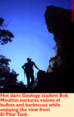
About a half-mile past Bath Tub Tank, a tributary feeds into the main course of Adobe Canyon. This little drainage is filled with deep grass and has a fence crossing it. This is the way to El Pilar Tank, the second dam on this watercourse built by the CCC. A 50-foot natural tower of sandstone lies next to it, overlooking a second pool far below.
After climbing a nearby hill and enjoying an incredible view of Mount Wrightson, we return the way we came. By now the light is fading fast, and by the time we get back to the truck we're in the dark. So much for shooting. Nevertheless our stomachs demand the grilling must not also fall victim to the power of night. We gather some wood, set our little grill afire and begin cooking some burgers.
At this time we realize the kitchen box with spatula and plates is waiting back in the garage. However, we do have a stack of 1970s-era albums we had planned to target shoot. Putting a pair of wire cutters to use, the vinyl from B. J. Thomas' Greatest Hits Volume 2 (neither Moulton nor I could fathom how he accumulated enough hits for volume 1) rapidly becomes a slowly melting spatula, and a couple Dennis Parker albums serve as plates.
Enjoying our fire-cooked meal and the quiet of the surrounding forest, I begin to question the advantage of moving out of the stone age, or at least the age of vinyl. Maybe when I'm a wizened old columnist I'll retire to this corner of the woods. Then I can spend all my time doing those things that I spend all week working for--hiking, shooting, grilling. It's not just an afternoon, it's a lifestyle.