|
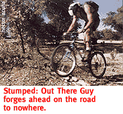
The Out There Gang Takes An Unrighteous Path. By Kevin Franklin MOUNTAIN BIKES EXCEL at getting me into trouble. When on foot, trailfinding or trailblazing can be a demanding task requiring skill and familiarity with the area. When on a mountain bike, it can be downright impossible. Ever in quest of new terrain to roll our human-powered machines through, the Out There pedal-pushers head into the Atascosa Mountains northwest of Nogales. Atascosa loosely translates from Spanish as "muddy" or "boggy." The mountains get their name from a marshy spring on the Bear Valley Ranch in the heart of the range, writes Byrd Granger in Arizona's Names.
The whole scene is very pioneer Arizona, and so, in the spirit of all-American wandering marauders, we start exploring the mountains with no real notion of what we'll do or encounter. Old ranch and mine roads twisting through these hills beckon the curious mountain biker. Looking at the Ruby 15-minute topographical map, we eye an old road that leaves the main Ruby-Nogales road (a.k.a. Forest Service Road 39) at Yank's Tank and shoots about two miles north toward the Tumacacori Mountains. Then it takes a 90-degree turn to the west and reconnects with the Ruby-Nogales Road. Our plan then is to create a six-mile loop by coming back on the main road. Ahhh, the plan. The best laid plans always seem to go to hell. I suppose we can't blame the map. Hearkening back to 1957, our topographical guide so little resembles present-day reality we might be better off basing our road decisions on a magic eight-ball.
You can see the upwelling of some water in the area from Yank's Spring. Yank Bartlett and his partner Hank Hewitt worked as teamsters and packers in the area (Yank & Hank's Full & Pull?) in the mid-1880s. Yank managed to get himself shot by one of Geronimo's band, but lived to tell the tale. We, too, got more than we bargained for from the locality. Things start off well as we glide through a level meadow shaded by giant cottonwood trees. As soon as the road climbs out of the meadow area it rapidly deteriorates into a cobble jumble. Not long after, it improves considerably, but basically this ride serves as an excellent short ride to test your rock hopping and climbing skills. As a pleasant loop it flounders, especially since it fails to connect with anything. For the less-experienced, this could be a real walk-a-lot hell-ride. Fervently wanting to complete our loop, we continue riding down 682, even as it dissipates into a cow track. At this point we stop and climb a nearby hill to see the main Ruby-Nogales Road off in the distance. By now we're certain our path has diverged from that of the righteous, and so we tuck in our tails and return whence we came.
GETTING THERE
Take Interstate 19 south to exit 289. Follow the Ruby-Nogales
Road west past the Peña Blanca Recreation area to the Sycamore
Canyon and the turn-off for Forest Service Road 682 and park a
little way in, past the corral. This trip might work best as an
afternoon ride ending in an evening camp-out, making the most
out of the two-hour journey there.
|
 |


Home | Currents | City Week | Music | Review | Cinema | Back Page | Forums | Search
| © 1995-97 Tucson Weekly . Info Booth |
||
 The Atascosas make an ideal destination for spring mountain bike
rides. The terrain fluctuates around 4,000 feet in elevation,
making it on average a good 10 degrees cooler than Tucson. The
country is principally rolling hills punctuated with pockets of
juniper and small oak trees. A couple members of our group consider
the area reminiscent of central California, à la San Luis
Obisbo or thereabouts. But crowning these rolling hills is Atascosa
Peak at 6,440 feet. Its accompanying two-mile-long ridgeline closely
competes with the peak in height most of the way.
The Atascosas make an ideal destination for spring mountain bike
rides. The terrain fluctuates around 4,000 feet in elevation,
making it on average a good 10 degrees cooler than Tucson. The
country is principally rolling hills punctuated with pockets of
juniper and small oak trees. A couple members of our group consider
the area reminiscent of central California, à la San Luis
Obisbo or thereabouts. But crowning these rolling hills is Atascosa
Peak at 6,440 feet. Its accompanying two-mile-long ridgeline closely
competes with the peak in height most of the way.
 However, finding Yank's Tank and Yank's Spring wasn't too much
trouble. At the bottom of a hill about seven miles west of the
Peña Blanca Lake recreation area we bump into Sycamore
Canyon and Forest Service Road 40. A few baseball throws farther,
the road crosses the drainage for Sycamore Canyon and heads off
to the left. To the right is Forest Service Road 682 and our intended
path.
However, finding Yank's Tank and Yank's Spring wasn't too much
trouble. At the bottom of a hill about seven miles west of the
Peña Blanca Lake recreation area we bump into Sycamore
Canyon and Forest Service Road 40. A few baseball throws farther,
the road crosses the drainage for Sycamore Canyon and heads off
to the left. To the right is Forest Service Road 682 and our intended
path.