
|
By Kevin Franklin LIVING IN OUR sunny state, you can lose empathy with the pain and suffering family and friends endure over the long winters in the frigid north and east. Well, a winter day trip in the Catalinas will help you remember what a snowflake looks like. For our winter outing, the Out There team chooses to slide down the Palisade Trail.
The Palisade Trail begins, appropriately enough, next to the Palisade Ranger Station, which naturally sits near Palisade Rock on Mount Bigelow. U.S. Forest Service Assistant Supervisor William John "Pop" Anderson believed the rock face resembled a stockade wall and therefore gave the formation its name back at the turn of the century. The Palisade Ranger Station was built by the Civilian Conservation Corps in 1935 to meet increasing recreation and management needs. After easily finding a parking space across from the ranger station, we amble back down the highway to Organization Ridge Road. The trail begins down the road past the Boy Scout Camp turn-off, but before the Girl Scout Camp. If you keep an eye out for the gated power line service road on your right, you'll see the marker indicating the trail closely after that, also on your right. Look for a small wooden marker with the number 99 on it. The well-worn trail begins here--and so does the fun. Underneath the protective green arms of these mighty ponderosa pines sits the ultimate ammunition of tomfoolery...snow. Snowballs are by far the best thing about winter, and one of the few things I miss about colder climes. After the obligatory snowball fight, I relive the lingering agony of a well-placed shot melting between my shirt collar and neck, and conclude I don't miss snowballs as much as I thought I did.
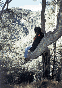
Even so, we're probably not as alone as the first fellows who built this trail at the turn of the century to ease access to Mount Lemmon and other points in the Catalinas. In The Santa Catalinas: A Description and History, Anne Harrison writes of how Cap Smith engineered the new route to the top back in 1911, with the Chamber of Commerce kicking in a whopping $500--half the cost--for the six-mile "Pine Ridge Trail," as it was then called. As we amble through the forest, nothing stirs the silence but the muffled sound of our footprints and the occasional cold breeze cutting through the treetops. We frequently come across movie ticket-sized flakes of Muscovite scattered on the ground. This reflective mineral is widespread in the granites of the Santa Catalinas, but finding a piece larger than a Frosted Flake takes a little looking. Around here, Muscovite is clear or white in color. The remarkably elastic mineral comes in flaky, irregularly shaped expanses. While we feel self-satisfied with our little find, in other parts of the world Muscovite comes in large sheets. In Russia, Muscovite was used as a glass substitute (hence the name), and is still used for windows in iron stoves. Tromping around these mountains and looking at the rocks, it takes a pretty powerful imagination to picture them where they were formed. Back in the Tertiary Period, more than 30 million years ago, these seemingly permanent rocks around us were part of the roiling magma chamber of a large volcano. After millions of years of bumping, grinding and uplift, they have arrived at their present--and temporary--position. A position ideally suited for ambushing my fellow hikers with heaps of snow. Farther on down the trail, we come to a bizarre pine tree that has formed a giant cradle with one of its branches. From this mighty ponderosa La-Z-Boy, we can see Spencer Peak and a panoramic view of forested slopes. Immediately beyond the strange tree, the forest opens up, and we are presented with a tremendous view of Sabino Basin. Beyond the basin and over the fore-range peaks, we can see Tucson sprawling across the valley below. With miles to go before we sleep and various promises to keep, we head back up to the road and home. As dusk falls on the forest and a cold wind stirs, our memory of long, frigid winters is sufficiently stoked to awaken our empathy for old friends, and the sense not to go back.
GETTING THEREFollow Catalina Highway past mile marker 19, and look for the Palisade Ranger Station to your left. Park in the parking area on your right, head back to the Organization Ridge Road and start your hike.
MAPAGE
The Santa Catalina Trail and Recreation Map will serve you well
on this adventure.
|
 |


Home | Currents | City Week | Music | Review | Cinema | Back Page | Forums | Search
| © 1995-97 Tucson Weekly . Info Booth |
||
 With the sun high in the sky and a balmy 75 degrees wearing away
at us, we head up the Catalina Highway in search of winter. The
skiing conditions on the mountain at this time still suck, and
since nearly everyone seems to consider the mountain a summertime
retreat, the place is relatively deserted.
With the sun high in the sky and a balmy 75 degrees wearing away
at us, we head up the Catalina Highway in search of winter. The
skiing conditions on the mountain at this time still suck, and
since nearly everyone seems to consider the mountain a summertime
retreat, the place is relatively deserted.
 Palisade Trail has that all-important element that makes mountain
hiking one of life's greatest pleasures (the downhill part anyway):
a squishy carpet of pine needles that muffles your footsteps.
A mile and a half from the car, we've left the last vestiges of
the city behind and stepped into Robert Frost's "Stopping
by Woods on a Snowy Evening." We're alone in the forest,
with not even a footprint in the snow to mark anyone else's crossing.
Palisade Trail has that all-important element that makes mountain
hiking one of life's greatest pleasures (the downhill part anyway):
a squishy carpet of pine needles that muffles your footsteps.
A mile and a half from the car, we've left the last vestiges of
the city behind and stepped into Robert Frost's "Stopping
by Woods on a Snowy Evening." We're alone in the forest,
with not even a footprint in the snow to mark anyone else's crossing.