|
Navigating The Wilds Of Arizona? Be Sure To Take Your Paper Clip. By Kevin Franklin THROUGHOUT HISTORY, GREAT advances in exploration move hand in hand with new navigational technologies.
But my favorite navigational tool is the paper clip. It's lighter than a compass, more durable than a sextant and considerably cheaper than a GPS unit. They even come in different colors. Lost my mind? Not hardly, though I do have to admit that without an odometer and a map, the paper clip is worthless as a navigational tool. You see, by taking a paper clip and marking it to match the hash marks on your map's mileage key, you can easily plot distances on the map. For instance, say two inches on your map equals six miles. You take two inches of your paper clip, bend it into a pattern matching the squiggly line of a road you're trying to follow, and, voila! You know how many miles it is from point A to point B. When you ring up six miles on your odometer, you should be at point B. This may sound somewhat anal--after all, with a map you should be able to just look around and figure out where you are. But a recent Out There adventure to the Cerro Colorado Mountains northeast of Arivaca proves the exception. We know we have to make a left turn onto a dirt track, and the distance from Batamote Ranch is a little under two-and-a-half miles. It all looks simple on paper, but weathered roads show blatant disregard for the intentions of cartographers. New roads spring up, old roads fade away. Simple instructions like, "take the first left," yield to problems like, "this is the first left, but the road seems too small and doesn't quite match the map."
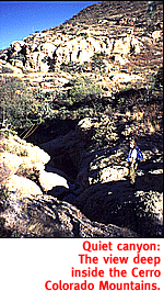
The particular stretch of road we want to follow is smack dab in the middle of four topographical maps. Imagine trying to shuffle back and forth between four maps on a breezy day. Placing your maps on the copy machine and making a new, hybrid map, especially a smaller one, will alleviate a great deal of frustration. Despite my inability to follow my own advice, we wind our way into the heart of the Cerro Colorado Mountains. These cliffy outcrops and thrusting spires are mostly solidified volcanic ash and reddish rhyolite. Ancient eruptions, violent and explosive, have now become an overlooked Arizona backwater. What I like about the Cerro Colorados is their quiet magnificence. Fantastic rock formations, beautiful mesquite forests and deep grass all hide in the heart of the range. Yet they are left, for the most part, to a few hunters and the local ranching outfit. We park the truck just past Wino Tank and begin hiking up the canyon. A cow track runs along the canyon bottom for about a half mile. After that, the trail reappears intermittently, but for the most part the hike is a bushwhack. About a mile in, the canyon splits. We take the right fork. Shortly thereafter we enter a stretch of shallow pools and channels cut into the rock by a millennium of erosion. It's a miniature Slickrock Canyon. Up ahead the route comes to an end in a box canyon. Climbing the walls of the canyon would give us a view of Las Guijas Mountains and Arivaca to the south, but the shadows are growing long. We head back to the truck and dinner underneath a starry sky and among the cliffs of Cerro Colorado.
Getting ThereTake Interstate 19 south to Exit 48, Arivaca Junction. Head west. Just past milemarker 19, take Batamote Road to the right. Stay on the main track, bearing left at the fork two miles in. Continue to Batamote Ranch on your left. Pass through the ranch, making sure to leave gates as you found them, and look for the road on your left, a little less than two-and-half miles on, and continue to Wino Tank.
Mapage
Saucito Mtn., Cerro Colorado, Peñitas Hills and Batamot
Hills 7-1/2 minute topographical maps will get you there in style.
|
 |


Home | Currents | City Week | Music | Review | Cinema | Back Page | Forums | Search
| © 1995-97 Tucson Weekly . Info Booth |
||
 The compass allowed sailors to move away from the coastline in
foul weather and still keep their bearing. The sextant enabled
trans-Atlantic explorers to chart their movements. Most recently,
global positioning system units have given hikers their precise
location by satellite.
The compass allowed sailors to move away from the coastline in
foul weather and still keep their bearing. The sextant enabled
trans-Atlantic explorers to chart their movements. Most recently,
global positioning system units have given hikers their precise
location by satellite.
 Fortunately, Out There's stumble luck holds, and we follow a
series of other roads back to the point we wanted to reach from
the first road. But here's where we need another handy navigational
tool, the copy machine.
Fortunately, Out There's stumble luck holds, and we follow a
series of other roads back to the point we wanted to reach from
the first road. But here's where we need another handy navigational
tool, the copy machine.