 A Trek To The Dripping Spring Mountains Inspires A Bit Of Poetry, Or Vice Versa. By Kevin Franklin THIS SUNDAY SCOTS around the world and fans of poet Robert Burns will celebrate Bobbie Burns Day. What better way to mark his birthday than to climb Tam O'Shanter Peak in the Dripping Spring Mountains near Winkleman? The title of Burns' masterpiece and the name of the protagonist in the poem, Tam O'Shanter, became synonymous with the Scottish beret-like cap with a pompom at its center. The peak in the Arizona mountain range received its name because it supposedly looks like a tam-o'-shanter. I set out to see for myself.
An old mine road runs parallel to O'Carroll Canyon. At nearly every bend, I take in the scenery like a starving man at a buffet. The vegetation is classic Sonoran: towering saguaros interspersed with lush palo verde and razor-sharp jumping cholla, their golden spines diffusing the light like an impressionist painting. Every quarter mile or so I stop the truck and gaze down the sheer cliffs of the limestone canyon. I'm on my way to the interior of the range, but this place warrants a return trip devoted to just the canyon. Dozens of smaller side canyons and dark crevices beckon to be explored, but tonight's plan is to camp within striking distance of the peak. When Burns died in 1796, the wilderness of these mountains was not only unspoiled, it was likely undiscovered by Europeans. It would be another hundred years before Phoenix would be a dot on the map, much less a large city. Even today, the only indication of anyone's having been here in days, if not weeks, is a faint pair of vehicle tracks on the road. As the light begins to fade, I am very much alone. Most folks know poet Burns for the song "Auld Lang Syne," the tune everyone sings a fragment of on New Year's Eve. A few others might recognize "O My Luve's Like a Red, Red Rose." But my personal favorite is "Tam O'Shanter," the story of a friendly, bumbling Scot who wanders down an empty road--one probably best left alone--sticking his nose in where it doesn't belong and getting into heaps o' trouble. Loyal readers of this column will note a certain similarity.
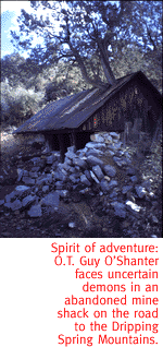
As he comes to the abandoned kirk, Tam peers inside to find the devil and host of hellish creatures playing music and reveling the night away. I am fast approaching an old mine shack lurking under a big juniper tree. I stop to investigate. The full moon, malignant orange, rises in the distance. (I'm not making this up.) I peer into the dark recesses of the shack--no devils, but my flashlight does reveal a human skull. It's painted on the ceiling with the word "Drugs" scrawled next to it in some creepy, stylized graffiti. I'm not sure if it's a warning or an endorsement. I decide to camp farther down the road. Tomorrow I'll climb the peak, assuming Cutty Sark doesn't steal me away in the night. Will our hero survive the treacherous slope of Tam O'Shanter Peak? Don't miss next week's harrowing adventure!
Getting ThereThe Dripping Spring Mountains are 65 miles north of Tucson, just past Winkleman off Highway 77. The road into O'Carroll Canyon is two and quarter miles north of the Highway 177 junction.
Mapage
The Hayden and Christmas 7 1/2 minute topographical maps
offer an effective guide through these mountains.
|
 |


Home | Currents | City Week | Music | Review | Books | Cinema | Back Page | Archives
| © 1995-97 Tucson Weekly . Info Booth |
||
 The Dripping Spring Mountains stand adjacent to the Gila River
Basin. The region is pocketed with copper-mining operations: To
the west lies the massive open-pit Ray Mine; on the northern flank
crouches the dormant Christmas Mine; and along the southern flank
are the Hayden smelting operations, with their massive tailings
ponds. Despite all of this surrounding industrial activity, the
range remains remote. It sees little recreational use, and after
a few minutes' drive off the beaten path, isolation from the modern
world is complete.
The Dripping Spring Mountains stand adjacent to the Gila River
Basin. The region is pocketed with copper-mining operations: To
the west lies the massive open-pit Ray Mine; on the northern flank
crouches the dormant Christmas Mine; and along the southern flank
are the Hayden smelting operations, with their massive tailings
ponds. Despite all of this surrounding industrial activity, the
range remains remote. It sees little recreational use, and after
a few minutes' drive off the beaten path, isolation from the modern
world is complete.
 Driving along the old mine road, I muse on the parallels between
old Tam's adventure and my own. While riding down the lonely road
to the abandoned kirk (church), and the town of Alloway, Tam has
visions of ghosts and murderers from the past. I don't see any
ghosts or murderers, but the cloudy skies and twilight cast the
canyon in a gloomy light, creating long shadows on dark rocks.
Driving along the old mine road, I muse on the parallels between
old Tam's adventure and my own. While riding down the lonely road
to the abandoned kirk (church), and the town of Alloway, Tam has
visions of ghosts and murderers from the past. I don't see any
ghosts or murderers, but the cloudy skies and twilight cast the
canyon in a gloomy light, creating long shadows on dark rocks.