|
On The Way Back From Los Angeles, The Desert Beckons. By Kevin Franklin SOMETIMES YOU NEED to get off the freeway. Poets might construe that as a call to arms against a culture of minute-to-minute rush and bottom lines. But I mean just what I say. Sometimes you need to pull off and explore the mountains.
The main eye-catcher about the Plomosas is the sprawling monolith of Black Mesa. Rising almost 2,000 feet from the surrounding desert, Black Mesa is the remnant of a 15-million-year-old basalt flow. The last hundred feet of elevation form a near-vertical cliff, effectively turning the mesa into an imposing dark fortress. It has several deep canyons incising into its southern flank, and an old road running within a few miles of it. In Roadside Geology of Arizona, Halka Chronic writes about the neighboring country: "Warped and folded Paleozoic strata and reddish Tertiary volcanic rocks are capped with dark Quaternary basalt flows. Caves form readily in the volcanic rocks." Dark, forbidding mesas, the allure of caves, easy access from the freeway. What more does a desert rat need? Returning from a weekend in the nightmare of Los Angeles, I decide to veer off the beaten path for some serious decompression time in the desert. I turn onto Highway 60, briefly heading toward Prescott. Just before the little hamlet of Brenda, I turn right onto Ramsey Mine Road. A well-graded road leads south, over a bridge, crosses the freeway and continues into the desert.
At the northern boundary for the New Water Mountains Wilderness Area, I park and continue on foot. From the pile of boulders and recently replaced Wilderness Area markers, the Bureau of Land Management clearly has had trouble keeping people from driving in here. If you want to drive, go to L.A. There are few places left in the world where you can't take a car. Enjoy them. It's an Arizona adage that all roads lead either to another road, cattle or a mine. Obviously, whoever bladed this road wanted to defy that notion. The road runs for another mile and then terminates, at the top of a hill. The view from here into the wide-open miles of the Kofa National Wildlife Refuge to the south does a lot to ease my urban angst. It also demands an amendment (places with a view) to the road adage. Happily, the last stretch of this road is rapidly reverting to desert. With the better part of a day remaining, I head down the peak and across desert terrain toward the foot of Black Mesa. From this side the giant slopes still demand respect, but along one ridgeline they offer the hope of ascent. No vertical cliff guards this approach, although about 50 million basalt boulders do. Stacked into a menacing, occasionally mobile talus slope, this army of stones turns out to be a fairly accommodating stairway to the top of the mesa. It just requires a certain tolerance for stairways that move--and a bit of faith that the whole enchilada isn't going to start cascading. Oh yeah, and a lot of sweat. I reach the top and lean back into a throne of black stone. The air is clear and crisp. The wind gusts now and then, but the sun on the basalt is warm. I retrace my route across the foothills and along the old road. Distant washes, jagged peaks and alluring nooks in remote canyons provide fodder for imagined adventures. To the north lies freeway and its speeding traffic. I resign myself to being among them soon enough. But for now, I'm enjoying the ride.
Getting ThereTake Interstate 10 to Exit 31, about 14 miles east of Quartzsite. Follow Highway 60 for three miles east to Ramsey Mine Road. Follow that south as far as you dare, or until you hit the Wilderness boundary. The New Water Mountains 7 1/2 topographical offers adequate mapage.
|
 |


Home | Currents | City Week | Music | Review | Cinema | Back Page | Forums | Search
| © 1995-97 Tucson Weekly . Info Booth |
||
 Take the Plomosa Mountains, for instance. Interstate 10 bisects
them. Tens of thousands of folks drive through them every day
to and from
Take the Plomosa Mountains, for instance. Interstate 10 bisects
them. Tens of thousands of folks drive through them every day
to and from 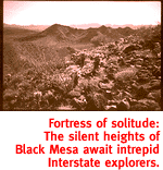 After about two miles, I take the left fork and keep to the
principal route. To say "principal" assumes a sense
of relativity about the condition of neglected desert roads. For
several long stretches, the road and a large sandy wash are one
and the same. In fact, the wash is considerably smoother than
the "road."
After about two miles, I take the left fork and keep to the
principal route. To say "principal" assumes a sense
of relativity about the condition of neglected desert roads. For
several long stretches, the road and a large sandy wash are one
and the same. In fact, the wash is considerably smoother than
the "road."