|
Hot Times In New Mexico's Valley Of Fires. By Kevin Franklin ICE CAVES? THERE are ice caves out there?" I ask, looking out across the forbidding black lava flow stretching into the distance. Heat waves from the summer sun shimmer across the flow's long-ago solidified surface. "There are a couple of them," says Cheryl Sparks, a volunteer for New Mexico's Valley of Fires Natural Recreation Site. "The blue of the ice in the caves is indescribable. It's bluer than ocean blue," she adds.
At this point I'm considering returning to the area for just such an expedition, when Sparks points out the Recreation Site is also the starting point for the bi-annual guided trip out to the Trinity Site on the White Sands Missile Range. On the first Sunday of May and October, the Air Force allows visitors access to the site of the first nuclear detonation. A morbid curiosity about the current condition of the Southwest's ultimate desert clear-cutting signals that I'll be coming back to see that, too. In the meantime, there's a lava flow to explore. My friends and I walk out of the Bureau of Land Management's visitor center and onto the Valley of Fires Malpais Nature Trail. This lava flow is thought to be the youngest of its kind in the continental U.S. About 1,000 years ago, molten lava erupted from a cinder cone to the north and spread southward. The flow stretches 44 miles from its origin near Carrizozo, New Mexico. In places the swirls and blobs of lava reach a depth of 165 feet and the flow ranges from two to five miles wide. I'm standing on an outcropping of sandstone that towered above the flow while a hellish river of molten rock flowed past. Native Hawaiians and geologists call these stone islands kipukas. While the kipuka I'm standing on wasn't overwhelmed by the flow, it didn't escape unscathed. The heat radiating from the lava flow would have incinerated most everything on this football field-sized outcropping. Where the tide of magma slid alongside the kipuka the heat was so intense it chemically altered the rock, turning it from yellow to pink, and in places even metamorphosing it into quartzite (melted sandstone).
Some folks didn't have to imagine it. While this flow was erupting, Jornada Mogollon people lived nearby in what today is called Three Rivers (see "Rock On," Tucson Weekly, August 6 ). What a site that must have been. Amazingly, the source for such a huge lava flow is a dinky little cinder cone called, predictably enough, Little Black Peak. Barely rising about the height of the flow, this tiny cone and its buried ancestors pumped out 127 square miles of magma. Despite the confusing trail guide, we have a great time wandering around the pressure ridges, collapse features and small lava tubes that dot the landscape. Eventually we head off the flow and toward lunch. With a final look back at the expanse of jumbled rock, I remember the ice caves hidden out there somewhere, waiting to be found. We'll be back.
Valley of Fires Recreation Area is located about 65 miles
north of Alamogordo, New Mexico, off Highway 54. For more information,
contact Valley of Fires Recreation Area, P.O. Box 871, Carrizozo,
New Mexico 88310; or call (505) 648-2241.
|
 |


Home | Currents | City Week | Music | Review | Books | Cinema | Back Page | Archives
| © 1995-97 Tucson Weekly . Info Booth |
||
 Sparks gives me general directions to the caves, but explains
that it takes the better part of a day to reach them by crossing
the rugged and broken lava flow on foot. Not being very familiar
with the backcountry part of the site, she's unable to give me
a precise location. No rangers are around today, and our time
doesn't allow for a spur-of-the-moment, two-day backpack tour
of the waterless malpais country.
Sparks gives me general directions to the caves, but explains
that it takes the better part of a day to reach them by crossing
the rugged and broken lava flow on foot. Not being very familiar
with the backcountry part of the site, she's unable to give me
a precise location. No rangers are around today, and our time
doesn't allow for a spur-of-the-moment, two-day backpack tour
of the waterless malpais country.
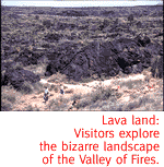 The solidified lava appears frozen in mid-action, like a stop-frame
image. It's easy to imagine this basaltic rock once flowing like
super-hot pudding.
The solidified lava appears frozen in mid-action, like a stop-frame
image. It's easy to imagine this basaltic rock once flowing like
super-hot pudding.