Graveyard Shift
Traipsing Through The 'Tombstones' Of Burned-Out Trees On AMount Lemmon Hike.
By Kevin Franklin IT LOOKS LIKE snow. A grove of ferns atop the Catalina Mountains appears to be buried in two inches of snow in June. In fact, they're dusted with tens of thousands of cottony aspen tree seeds.
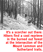
It's a comforting mirage. Though we're at 9,200 feet and 30 degrees cooler than Tucson, visible in the valley below, it's still sweating hot. We've already hiked the Lemmon Park Trail to the Mount Lemmon Trail, where we passed the aspens. We plan to follow Mount Lemmon Trail down to the Wilderness of Rocks Trail and then back up the little-used Lower Mount Lemmon Trail. All told, an eight-and-half mile trek. That doesn't sound like much, but it encompasses 4,000 feet of elevation change. On the Mount Lemmon Trail, we pass the Fortress. Looming 400 feet above the surrounding pines, the Fortress is aptly named. There are three giant outcrops here known as the Summit Crags. To the east of the Fortress lie the Ravens, a collection of jointed columns, and then Rappel Rock. The Fortress and The Ravens are closed to everyone in the summer because endangered peregrine falcons nest here. The 500-foot sheer faces of Rappel Rock draw gobs of climbers to the cooler climes. We peek through the undergrowth at the stony head of the Fortress and quietly continue on our way. Today's loop will take us all the way around the Summit Crags. Our next good view of them will be from thousands of feet below amid the Wilderness of Rocks, a jumble of giant boulders perched on top of one another. At the intersection of the Mount Lemmon Trail and Sutherland Trail, we enter the area of forest burned in 1994.
In the present, a few of the seeds in those berries have taken root elsewhere on this mountain and grown into trees already ancient in human terms by the time I pass their cremated ancestors. They will continue long after me. Even the graveyard itself will soon be more about the living than memories of the dead. Grasses and seedlings are sprouting where before there was not enough light to sustain them. Perhaps a few of the aspen seeds we saw earlier will blow over here and take root, using this clearing just like the trees they came from used another clearing many years ago. Seeing the young trees is like seeing the grandchildren of a good man visiting his grave. We pass through the quiet forest and on toward our rendezvous with the Wilderness of Rocks Trail. We follow that trail down to Lemmon Creek, which usually runs, at least a little bit, all summer long. Even in this record drought there are a few puddles left, but no moving water. We press on. The second time we cross Lemmon Creek we find the Lower Mount Lemmon Trail junction. About a mile onto this trail is where the going gets tough. Along a half-mile stretch of this steep two-mile trail, the path climbs 800 feet. That means for every two feet forward, we're climbing more than a half-foot up. That's like climbing a half-mile-long set of stairs. Trudging along, we eventually reach the top, seven hours after our departure. Low on water and exhausted, we rejoice at returning to the meadow of fuzzy snow.
GETTING THERE
Take the Catalina Highway all the way to the top, past the ski
resort. The trail starts at the designated parking area just below
Steward Observatory. Mapage: The Santa Catalina Recreation
Map is just the thing for this trip.
|
 |


Home | Currents | City Week | Music | Review | Cinema | Back Page | Forums | Search
| © 1995-97 Tucson Weekly . Info Booth |
||
 Vaguely similar to dandelion spores, the aspen progeny launch
themselves from hundreds of catkins 30 feet up in the air. Catkins
look like cocoons, but are really the flowers of the aspen tree.
After pollination, the seeds and their puffy parachutes grow on
the catkin. With the slightest breeze they drift to the forest
floor like a mid-summer snowstorm.
Vaguely similar to dandelion spores, the aspen progeny launch
themselves from hundreds of catkins 30 feet up in the air. Catkins
look like cocoons, but are really the flowers of the aspen tree.
After pollination, the seeds and their puffy parachutes grow on
the catkin. With the slightest breeze they drift to the forest
floor like a mid-summer snowstorm.
 Burned forests remind me of graveyards--beautiful, solemn graveyards.
It seems to me graveyards are more about life than death. A grave
stands as a final monument to a life, a sort of summary. Looking
at the burned trunks and blackened floor, my imagination takes
me to this place before the fire. In my mind, the twists and bends
in the arms of a giant alligator juniper become lush again. I
see it through hundreds of years as literally millions of berries
are carried off this tree by hungry birds.
Burned forests remind me of graveyards--beautiful, solemn graveyards.
It seems to me graveyards are more about life than death. A grave
stands as a final monument to a life, a sort of summary. Looking
at the burned trunks and blackened floor, my imagination takes
me to this place before the fire. In my mind, the twists and bends
in the arms of a giant alligator juniper become lush again. I
see it through hundreds of years as literally millions of berries
are carried off this tree by hungry birds.