|
Out There Guy Tests The Waters In El Golfo. By Kevin Franklin WE CATCH QUICK glimpses of the sea through the dunes as we roll down Sonora Highway 40 toward El Golfo de Santa Clara.
With those harsh borders, the region east of El Golfo known as Bahía del Adair becomes a place where the sea dominates human activity. As such, we come prepared for water adventure. Cap'n Dave's Dive Center & Ship Store over on Speedway rents sea kayaks that you can take into Mexico, which makes sense considering the limited seashore in Arizona. After passing through the little fishing town with the two kayaks strapped on top of our truck, we head down the beach. While gringo hotels and contaminating English signs have yet to overrun this area, Bedouin gringos populate the nearby beaches. Like the nomadic Arabs of North Africa and the Middle East, these tribes of gringos move in familial units of 10 to 30, live in gigantic tents and carry their entire culture with them, including everything from stereos to Bud Lite. The old gringos spread out vast tracts of astro-turf to walk on to simulate their synthetic homeland, presumably somewhere near the Ohio River Basin. We avoid these clans and head down the beach. The farther you go from the town and pavement, the less likely it is you'll run into these bands. One thing you must deal with are the tides. Cap'n Dave's sells tide charts for the Sea of Cortez. The one for Puerto Peñasco is close enough for El Golfo. Plan your beach journey to coincide with low tide. Most of the beach can be navigated at high tide, but there are several points extending out into the sea that become enveloped in truck-eating ocean. There are several ways to drive on the beach, all of them rough on your vehicle. If you drive close to the water, the sand is harder and easier going, but you get a lot more corrosive salt water on your truck. In a few places the sand peters out and turns into mud capable of sucking in even the best 4x4. A winch and bunch of shovels might be the minimum to get you out. Remember the tides here can fluctuate more than 20 feet, so if you get stuck below the high tide mark you'd better get out in a hurry.
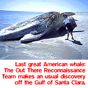
The choice is yours--fast and dangerous, or slow, tough and safe. Sadly, one of the most common sights on the beach are dead dolphins. While the cause of death is impossible to determine from the decayed bodies, there seems too many for them to all have died from natural causes. A few biologists suggest they probably drowned in some of the many nets extending off the beach or from the trawlers plying the sea. These are the common Pacific bottle-nosed dolphin, not the endangered vaquita porpoise that also lives in the northern end of the sea. Flipper's cousins are not the only marine mammals to wash ashore here. We also come across a beached baleen whale. Looking into the lifeless eye of the leviathan troubles the soul, but astounds the senses. We spend a few minutes upwind staring at the giant creature, wondering what caused its demise. At the end of the beach, we pass a wrecked lighthouse and come upon a tidal estuary. Places like this are the womb of the sea. They provide a protected place for juvenile fish and crustaceans to grow. Riding the tide, we kayak through a droplet of this mysterious and miraculous sea, all the while wondering what we'll see next.
GETTING THERECross the Mexican border at San Luis Rio Colorado south of Yuma and follow the signs directing you south to El Golfo de Santa Clara and Highway 40. The mostly paved road passes through town and to the beach.
The Mexican topographical San Felipe 1:250,000 map available
at Tucson Map & Flag covers the area nicely.
|
 |


Home | Currents | City Week | Music | Review | Cinema | Back Page | Forums | Search
| © 1995-97 Tucson Weekly . Info Booth |
||
 This area is a unique little pocket of northwestern Mexico. It's
bordered by the Colorado River Delta to the west, the 4,800 square
miles of sifting sand dunes of the Gran Desierto to the north,
and the giant shield volcano of the Pinacates to the east.
This area is a unique little pocket of northwestern Mexico. It's
bordered by the Colorado River Delta to the west, the 4,800 square
miles of sifting sand dunes of the Gran Desierto to the north,
and the giant shield volcano of the Pinacates to the east.
 If you drive higher up on the beach, the sand is softer and
heavy trucks with narrow tires will sink. Letting the tire air
out to about 15 pounds and avoiding sand banks will help, but
the strain of driving through deep sand can heat up the engine,
so keep an eye on the temperature gauge. If all you have is an
idiot light, slap yourself and go have an actual gauge installed.
If you drive higher up on the beach, the sand is softer and
heavy trucks with narrow tires will sink. Letting the tire air
out to about 15 pounds and avoiding sand banks will help, but
the strain of driving through deep sand can heat up the engine,
so keep an eye on the temperature gauge. If all you have is an
idiot light, slap yourself and go have an actual gauge installed.