By Kevin Franklin FROM THE BEGINNING of time, the good people of Tucson have looked to the mountains named for their shining city and said, "Nope, there's no single map that covers the whole range."
Well, sort of. In years past the lack of a comprehensive map was annoying. Most other oft-traveled mountain chains around here have their own recreational maps. The Santa Catalina, Santa Rita and Chiricahua ranges all have recreational maps that show topographical lines, recognized hiking trails and access points. And, unlike the United States Geographical Survey maps, they cover the whole range, as opposed to dividing it into arbitrary sections. With USGS Maps, it seems inevitable that whichever direction you plan your hike, you cross at least two or more maps. But the "Tucson Mountain Regional Park" trail map (the former premiere map for the southern half of the Tucson Mountains) takes the Oscar for oddball cartography. It covers only Tucson Mountain Park, and nary an anthill outside those arbitrary boundaries. The result is a map that looks like an abused congressional district gerrymandered into spindly peninsulas. If you follow Kings Canyon Trail on this map you simply disappear into a white void once you cross into Saguaro National Park, even though plenty of space remains on the map's paper. The Trails Illustrated Map eliminates the partisan nonsense and illustrates both the Rincon Unit of Saguaro National Park and county and federal park land in the Tucson Mountains--with the notable exception of Cat Mountain and the Kennedy Park Trail on the southern extension. Along with the omission of Cat Mountain, several accuracy and clarity problems cropped up in our field check of the new map--though for the most part those seem to be carried over from the aforementioned ridiculous Tucson Mountain Regional map. For starters the map fails to note Gates Pass Trail is accessible from the parking pullouts along Gates Pass Road. It also puts one of the parking pullouts on the wrong side of the road.
On the map the route is very clear. Finding the way on the ground is another matter. The map indicates a trail starting due north of the Kinney/Gates Pass intersection. The route is, however, a road considerably to the east of the intersection. The road and other information was intentionally left off the maps, says Trails Illustrated co-owner Mary Kay Stoehr. "We try to help protect the resource by putting on the map only what is established for the park," says Stoehr. "But, of course, if we take the roads off, it's confusing when you're on the ground." I can see Stoehr's point, but in a case like this, it seems way too much like the old Soviet policy of providing crummy maps to the public lest invaders use the information. In our case, it results in our traipsing around looking for a trail that doesn't exist, all the while quite sure the map could not mean the graded road we kept seeing. Stoehr says they kept the quantity of the first printing down in order to make revisions on new maps, so hopefully many of the bugs will get worked out this year. She says her company is always eager to hear from map users who might be able to point out things in need of correction. The bottom line here is you have to be some kind of idiot to get lost in the Tucson Mountains anyway. Since the map is topographically accurate, bringing a compass and doing a little orientation or even using some dead reckoning, like we eventually did, will put you on track. What makes the map useful and a must-have for Tucson hikers is its comprehensive nature. It provides a wellspring of ideas by showing what's out there--if not exactly where.
GETTING ONE
The Trails Illustrated Saguaro National Park Map is available
for $8.95 at Tucson Map and Flag, Summit Hut and Saguaro National
Park visitor centers.
|
 |


Home | Currents | City Week | Music | Review | Cinema | Back Page | Forums | Search
| © 1995-97 Tucson Weekly . Info Booth |
||
 But today we can cast away that cloak of ignorance. Now we have
the "Trails Illustrated Saguaro National Park Topo Map"
to clear away all doubt and disorientation.
But today we can cast away that cloak of ignorance. Now we have
the "Trails Illustrated Saguaro National Park Topo Map"
to clear away all doubt and disorientation.
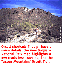 While those faults were relatively minor, we found more troubling
problems after venturing deeper into the terrain. We were inspired
by the new map to check out Orcutt Trail, one of the more obscure,
less-traveled routes in the Tucson Mountains. Orcutt Trail heads
off to the north, roughly from the intersection of Gates Pass
and Kinney Roads.
While those faults were relatively minor, we found more troubling
problems after venturing deeper into the terrain. We were inspired
by the new map to check out Orcutt Trail, one of the more obscure,
less-traveled routes in the Tucson Mountains. Orcutt Trail heads
off to the north, roughly from the intersection of Gates Pass
and Kinney Roads.