|
Big Guns, Bighorn And A Vast, Lonely Desert. By Kevin Franklin SPENT .50 CALIBER rounds litter the ground. A crumpled aluminum tow-dart glimmers amid dark basalt boulders, and the desert stretches as far as the eye can see. While it may sound like the Out There reconnaissance team has landed on the Kuwaiti frontier, we're actually in the heart of the Cabeza Prieta National Wildlife Refuge. Our plan is to climb Cabeza Prieta Peak, the namesake of this 860,000-acre sweep of wild desert.
When going onto the refuge, the U.S. Fish and Wildlife Service requires visitors to carry a permit and sign a "hold harmless" form. While the military doesn't fire live rounds over the refuge anymore, every once in a while something drops from the sky. Also, there are plenty of old munitions on the ground waiting for the intellectually impaired to come and monkey with them. In these litigious times, if some joker insists on blowing himself to kingdom come, it won't be at taxpayer expense. When I was here seven years ago hiking with a group of UA students, one of them thought it would be a swell idea to make a bandoleer. When air crews conducted target practice out here, they used to clear their weapons before returning to base. When you cleared a .50-caliber machine gun in the old planes, it would often hurl a live round out of the aircraft and onto the ground. Thirty years later, this student began picking up old rounds and the connecting pieces that hold the cartridges in a string. The bonehead started picking up live rounds. Gunpowder can become unstable over time. If just one of those rounds on his Pancho Villa accessory outfit went off, not only would it have torn him to ribbons, but everyone standing around him. Without being in a chamber, the cartridge could explode in all directions--like a hand grenade--as I quickly informed him. On today's hike, we're unencumbered by morons. Cabeza Prieta Peak is not the highest point in the refuge, nor even in its own range, but it's certainly one of the most striking. Cabeza Prieta translates to "Dark Head," most likely due to the dark andesite lava that erupted amid the peak's white granite. The stark contrast is visible from many miles away. Less apparent is the route ascending the peak--no foot trails or signs mark the way. This is deep wilderness, and hikers are on their own. From past experience, we know the surest way up the 2,559-foot mountain is the eastern flank. To get there requires a five-and-a-half-mile hike across the desert, through thick patches of teddy-bear cholla and broken ground.
At the saddle, the final leg to the peak is straightforward, if not exactly easy. The mountains here aren't large, but they're definitely steep and rugged. At several points we scramble along knife-edge ridges that are scarcely a foot wide. Then, from around a corner we spot several bighorn sheep. We stop to watch them, and they stop to watch us. The longer we sit quietly, the more sheep we spot. There are at least eight of them, many stout rams. After giving us a thorough reading, they decide it's time to bug out and race down the slope. They descend in a few minutes what was more than an hours' climb for us. We reach the peak and take in the view. The trail register at the top goes back to the mid-'60s, and until recently, there were very few names in it. Even now it's been months since the last entry. We add ours to the august list and leave the mountain to the sheep. Next week: Riding the Devil's Highway!
Getting ThereFor more information, you can write to the Fish and Wildlife Service at 1611 N. Second Ave., Ajo, Arizona 85321. Call 1-602-387-6483 to secure a free permit to enter the area.
Mapage
The Cabeza Prieta and Tule Wells 7 1/2-minute topographical maps
cover the refuge well. You may also want maps covering the length
of El Camino del Diablo, the only way to the starting area south
of the peak.
|
 |


Home | Currents | City Week | Music | Review | Books | Cinema | Back Page | Archives
| © 1995-97 Tucson Weekly . Info Booth |
||
 The .50-caliber shells have been out here for decades, from the
time when the military still fired live rounds over the refuge.
The dart probably landed here after being shot down during military
target practice, back in the '60s or '70s.
The .50-caliber shells have been out here for decades, from the
time when the military still fired live rounds over the refuge.
The dart probably landed here after being shot down during military
target practice, back in the '60s or '70s.
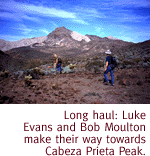 We cross-cut through three canyons at their lowest points until
we find a shallow slope that winds up to a wide saddle separating
the peak from the rest of the range. Any kind of rock-climbing
around here can be extremely dangerous. The rocks have been exposed
to the elements for a long time, and are what climbers call "rotten."
They crumble readily in the hand and can convey a false sense
of security at crucial points.
We cross-cut through three canyons at their lowest points until
we find a shallow slope that winds up to a wide saddle separating
the peak from the rest of the range. Any kind of rock-climbing
around here can be extremely dangerous. The rocks have been exposed
to the elements for a long time, and are what climbers call "rotten."
They crumble readily in the hand and can convey a false sense
of security at crucial points.