
|
By Kevin Franklin I BLINDLY SEARCH for a hold on the knobby granite surface above my head. Finding a small purchase, I pull myself upward, though a catclaw acacia sinks its hooked barbs into my bare calf. The anger of determination flows over me and, not wanting to lose the progress I just made, I yank my leg out of the bush. I pay for my freedom with a flesh-and-blood donation--neither the first nor the last bounty I'll pay while climbing the monstrous rock in the Santa Rita Mountains called Elephant Head.
There may be a safe ascent from the south face, but I never found it that day two years ago. Secretly, I'm convinced the old man sent me that way simply to smirk at my scarred attempt. However, now that I'm older, wiser and have more able friends who really do know the way, I return to my granite nemesis.
The easiest approach to Elephant Head begins by following a new mountain-biking trail down from the KMSB Radio tower road, a.k.a. Forest Service Road 183. The trail descends into Chino Basin where it hooks up with an old mine road. Turn right on the mine road, following it uphill and around the radio tower mountain. As you round the bend and start heading almost due north, the seemingly sheer walls of Elephant Head come into view. Once you round the radio tower mountain and start heading southeast, you have a choice to make--and both of them involve bushwhacking across rugged terrain. The more direct route descends along the steep slope directly south of the gap between Elephant Head and Pete Mountain. Going this way takes you through some pretty rough territory, though if you choose the right path none of it will be vertical. The other route follows the old mine road to its termination and then swings around and heads toward the mountain gap. Going this way adds a mile and a half to the hike, but it follows a more gradual grade. This route also takes in the Quantrell Mine. First worked in the early 1900s, the mine saw its last days in 1914. During production years, the Elephant Head Mining Company managed to extract some galena, chalcopyrite, pyrite and about 11 ounces to the ton in silver. That was enough to make the mine profitable, but not particularly noteworthy. Some of the headframe and a substantial pile of tailings remain. What really boggles the imagination is the road itself. If you look on the downhill side, you realize the entire base of the road was built by hand-stacked rocks. If it were on a flat surface, this road would look like a miniature Wall of China, which would not be entirely inappropriate, since most of the work here was done by Chinese laborers.
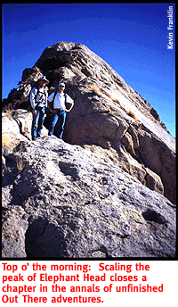
Once you reach the flat gap at the eastern base of Elephant Head, look for a trail occasionally marked with cairns. By following this semi-trail up the eastern spine of Elephant Head, the peak can be reached without exposing you to the 1,000-foot drops other approaches would. If you find yourself edging out onto a cliff, go back--there's an easier way. The final assault is tiring, but straightforward. The top of the rock offers spectacular views of the Sierrita, Baboquivari and Patagonia mountains as well as Tucson and Nogales. The return trip is easier, since you have a clear picture of where you're headed and the tough parts are downhill this way. Long pants are a must for this bushwhack hike because of all the acacia and shindaggers. This hike also requires a pretty good supply of energy and determination, even taking the sensible eastern course. But if you employ a little elephant-like wisdom, conquering the Santa Ritas makes a good day hike.
GETTING THERETake Interstate 19 South to the Canoa Road exit (No. 56). Head east by going under the Interstate and following the signs to Elephant Head Road, continuing east after the intersection. After about six miles, take Mount Hopkins Road to your right. Follow this paved road for a little more than five miles. Look for the dirt Forest Service Road 183 to your left. A sign indicating the KMSB Radio tower and Agua Caliente Wash marks the road. Immediately before the road crosses the wash and makes a sharp bend, look for the parking area on your right. The trailhead starts about 100 feet before the parking area. A mountain-bike trail marker is posted on the west side of the road.
MAPAGE
The Mount Hopkins 7 1/2 minute topographical map will make your
adventure much more enjoyable.
|
 |


Home | Currents | City Week | Music | Review | Cinema | Back Page | Forums | Search
| © 1995-97 Tucson Weekly . Info Booth |
||
 My rock-scrambling companion withered out a few hundred feet
down, but having come this far, I'm determined to find a means
to scale this behemoth. A wicked old man of my acquaintance assured
me Elephant Head could be climbed from the south face. I continue
until balked by sheer walls of granite. I turn back, deciding
foolhardy determination generally leads to just plain old termination...
My rock-scrambling companion withered out a few hundred feet
down, but having come this far, I'm determined to find a means
to scale this behemoth. A wicked old man of my acquaintance assured
me Elephant Head could be climbed from the south face. I continue
until balked by sheer walls of granite. I turn back, deciding
foolhardy determination generally leads to just plain old termination...
 Elephant Head stands like the Rock of Gibraltar at the western
edge of the Santa Rita Mountains. If you look south from Tucson,
you can see it as a rounded mass with a near-vertical drop on
the western side. It rises to a lofty 5,641 feet, more than 2,000
feet of vertical rise over the surrounding plain. That makes it
a considerably taller mass than the famed Gibraltar.
Elephant Head stands like the Rock of Gibraltar at the western
edge of the Santa Rita Mountains. If you look south from Tucson,
you can see it as a rounded mass with a near-vertical drop on
the western side. It rises to a lofty 5,641 feet, more than 2,000
feet of vertical rise over the surrounding plain. That makes it
a considerably taller mass than the famed Gibraltar.
 We take the Quantrell route on the way there. After crossing
the canyon bottom, both the direct and the Quantrell routes follow
the slopes of Pete Mountain to the eastern foot of Elephant Head.
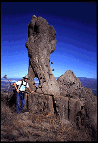
We climb up to the granite rock piles east of Elephant Head and
encounter some of the strangest rock formations I've ever seen.
We take the Quantrell route on the way there. After crossing
the canyon bottom, both the direct and the Quantrell routes follow
the slopes of Pete Mountain to the eastern foot of Elephant Head.
We climb up to the granite rock piles east of Elephant Head and
encounter some of the strangest rock formations I've ever seen.